
Imagine a city where planners can test new ideas, predict problems, and make smarter decisions without breaking ground or spending millions. That’s the power of digital twins—a game-changing technology that’s transforming how we design and manage our cities. A digital twin is like a virtual replica of a city, built with real-time data, that lets planners see how everything works together, from traffic to energy to buildings. In this article, we’ll dive into how digital twins are shaking up urban planning, making cities smarter, greener, and better for everyone.
What Are Digital Twins, Anyway?
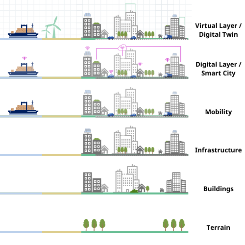
Let’s start simple. A digital twin is a digital copy of something real—like a city, a building, or even a road. It’s not just a 3D model or a fancy map. It’s a living, breathing virtual version that’s constantly updated with data from sensors, cameras, and other sources. Think of it like a video game version of a city, but instead of playing, planners use it to test ideas and solve problems.
For urban planning, digital twins pull in data about traffic patterns, air quality, energy use, population growth, and more. This creates a super-detailed picture of how a city works right now and what might happen in the future. Want to know what happens if you add a new subway line or build a skyscraper? A digital twin can show you before you spend a dime.
The idea isn’t brand new—NASA used digital twins to simulate spacecraft decades ago—but it’s only recently that we’ve had the tech to make them work for something as complex as a city. Now, with fast computers, tons of data, and smart software, digital twins are becoming a must-have tool for urban planners.
Why Cities Need Digital Twins
Cities are growing fast. By 2050, about 70% of the world’s population will live in urban areas. That’s billions of people needing homes, jobs, transportation, and clean air. Planning for all that is tough, especially when cities are already dealing with traffic jams, pollution, and aging infrastructure. Old-school planning—think paper maps and endless meetings—can’t keep up.
Digital twins solve this by giving planners a crystal-clear view of what’s going on. They can spot bottlenecks, predict floods, or figure out where to put new parks. Instead of guessing, they’re making decisions based on hard data. Here’s why cities are jumping on board:
- Saves Money and Time: Testing ideas in a digital twin is way cheaper than building something and hoping it works. If a new road causes traffic chaos in the model, you can tweak it before construction starts.
- Handles Complexity: Cities are crazy complicated, with millions of moving parts. Digital twins tie everything together in one place, so planners can see the big picture.
- Boosts Sustainability: Want to cut carbon emissions or save energy? A digital twin can show you how. For example, it can model how solar panels or green roofs affect a neighborhood’s energy use.
- Engages Communities: Some cities let residents interact with digital twins, so they can see proposed changes and give feedback. It’s like giving people a sneak peek of their future city.
How Digital Twins Work in Urban Planning
So, how do you build a digital twin of a city? It’s not like you can just scan a whole metropolis with a giant photocopier. Here’s a quick rundown of how it comes together:
- Gather Data: Cities are full of data sources—traffic cameras, weather stations, utility meters, even smartphones. Planners collect this info, along with maps, building blueprints, and satellite images.
- Build the Model: Using powerful software, they create a 3D virtual city. This includes roads, buildings, pipes, and power lines. The more data, the more accurate the model.
- Add Real-Time Updates: Sensors around the city feed live data into the twin. For example, if a road is congested, the digital twin shows it instantly.
- Run Simulations: Planners use the twin to test scenarios. What if we add a bike lane? What happens during a heatwave? The model predicts the outcomes.
- Make Smarter Plans: Based on the results, planners decide what to build, fix, or change. They can keep tweaking the twin as the city evolves.
It’s like having a crystal ball, but instead of magic, it’s powered by data and tech. Cities like Singapore, Dubai, and Helsinki are already using digital twins to plan smarter.
Real-World Examples of Digital Twins in Action
Let’s look at some cities that are using digital twins to make life better for their residents. These examples show just how powerful this tech can be.
Singapore: The Smart City Pioneer
Singapore is a small island with a big population, so space is tight. To stay ahead, the city built one of the world’s first digital twins, called Virtual Singapore. It’s a super-detailed 3D model that includes every building, road, and tree. Planners use it to test everything from new skyscrapers to flood defenses.
For example, Singapore’s digital twin helped plan a new eco-friendly district. By simulating sunlight, wind, and energy use, planners figured out where to put solar panels and green spaces to keep the area cool and sustainable. Residents can even access parts of the twin to check out proposed changes, like new parks or transit hubs.
Helsinki: Planning for People
Helsinki, Finland, is using a digital twin to make the city more livable. Their model pulls in data on traffic, air quality, and energy use to create a virtual version of the city. One big win: they used it to plan a car-free zone in the city center. The twin showed how closing streets to cars would affect traffic, deliveries, and even noise levels. The result? A quieter, cleaner downtown that’s great for pedestrians.
Helsinki’s twin also helps with climate goals. By modeling energy use in buildings, the city found ways to cut heating costs and reduce emissions, keeping winters cozy without harming the planet.
Dubai: Building the Future
Dubai loves big ideas, and its digital twin is no exception. The city’s model covers everything from its famous skyscrapers to its sprawling road network. Planners use it to test futuristic projects, like hyperloop stations or drone delivery routes. The twin also helps with everyday stuff, like figuring out where to add more bus stops or how to handle crowds during big events.
One cool use? Dubai’s twin helped optimize energy use in its desert climate. By simulating heat patterns, planners designed buildings that stay cooler, cutting down on air conditioning costs and saving energy.
The Benefits Keep Stacking Up
Digital twins aren’t just a shiny new toy—they’re delivering real results. Here’s a closer look at the perks they bring to urban planning:
- Traffic Taming: Congested roads are a pain. Digital twins can test new traffic signal timings, road layouts, or public transit routes to keep cars moving. Some cities have cut commute times by 15% or more using these models.
- Disaster Prep: Floods, earthquakes, or storms can cripple cities. Digital twins simulate disasters, so planners can spot weak points and build stronger defenses. For example, a coastal city might use a twin to plan flood barriers.
- Green Living: As cities fight climate change, digital twins help them go green. They can model how planting trees or adding bike lanes cuts pollution or how smart grids save energy. Some cities have slashed emissions by 20% with twin-guided plans.
- Better Housing: With populations booming, cities need more homes. Digital twins show where to build housing without wrecking green spaces or overloading roads. This helps create affordable, livable neighborhoods.
- Community Power: Digital twins let residents see what’s planned for their city and share their thoughts. This makes planning more transparent and builds trust between cities and their citizens.
What’s Holding Digital Twins Back?
Nothing’s perfect, and digital twins have their hurdles. For one, they’re pricey to build. Creating a detailed model and setting up sensors takes serious cash, which can be tough for smaller cities. There’s also the tech challenge—cities need fast internet, powerful computers, and skilled workers to make it happen.
Privacy is another issue. Digital twins rely on tons of data, and some worry about how it’s collected and stored. If a twin tracks where people go or how they use energy, it needs to be secure to avoid misuse. Cities have to be upfront about what they’re collecting and why.
Finally, not every city has the know-how to use digital twins. Training planners and getting everyone on board takes time. But as the tech gets cheaper and easier to use, more cities are starting to jump in.
The Future of Urban Planning with Digital Twins
So, what’s next for digital twins? As tech gets better, they’re only going to get more powerful. Here’s what we might see in the coming years:
- AI-Powered Twins: Artificial intelligence could make digital twins even smarter, predicting problems before they happen and suggesting fixes. Imagine a twin that warns you about a traffic jam before it starts.
- City-Wide Networks: Instead of one twin per city, we might see regional or even global networks of twins sharing data. This could help tackle big issues like climate change or migration.
- Virtual Reality Planning: Planners could “walk” through a digital twin using VR headsets, seeing proposed changes up close. Residents could join in, too, making planning more interactive.
- Smaller Cities Join In: As costs drop, smaller towns and suburbs could get their own digital twins, spreading the benefits beyond megacities.
Wrapping It Up
Digital twins are changing the game for urban planning. They’re giving cities a way to test ideas, save money, and build a better future for their residents. From cutting traffic to fighting climate change, the possibilities are huge. Sure, there are challenges—cost, privacy, and tech hurdles—but the payoff is worth it. As more cities embrace digital twins, we’re heading toward a world where urban planning is smarter, greener, and more inclusive. The cities of tomorrow are being built today, one virtual model at a time.


